NASA took a stunning picture of Boston at night. Here’s what it looks like over a regular map.
I can see my house from here!
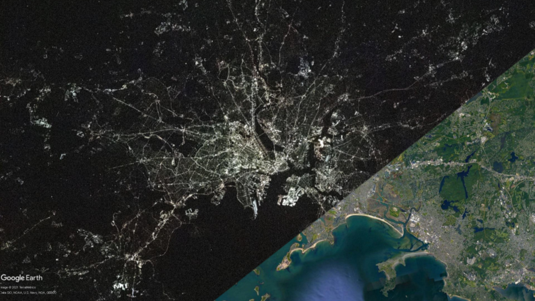
You can debate all you like on whether Boston truly deserves to be called “the Hub of the Universe,” but an exquisite aerial photo from hundreds of miles overhead sure makes the city feel like it.
In case you missed it, NASA shared a stunning photo of Boston at night shot from the International Space Station 263 miles above the surface earlier this month. It got over 800,000 likes on Instagram and caught the attention of the Boston subreddit this week.
https://www.instagram.com/p/CJzOskFJx7Q/
“Much like the delicate filaments of a spider’s web, the lights of the city of Boston seemingly spread from a central point,” NASA wrote.
Compression and resizing don’t do the shot justice, so make sure to check out the full-resolution photo if you want to explore further. The image is oriented toward the west, so if you don’t quite recognize what you’re looking at, turn your head to the right. Suddenly, the familiar shape of the Commonwealth’s eastern coastline comes into view.
Then, by carefully overlaying NASA’s image onto existing satellite imagery in Google Earth, we can get a more solid geographic foundation of what those astronauts saw. Here are some of the highlights worth examining in that aerial shot.
GIFs may take a moment to load. You can maximize them to get a closer look.
Greater Boston
It’s difficult to determine the exact extent of the NASA image, and it doesn’t help that it’s presented at an unfamiliar angle, so this comparison provides some context for the area that we’re actually looking at. With Boston in the center, the photographed area stretches north toward Wilmington and Salem, south toward Norwood and Randolph, and west toward Waltham.
The contrast between the dense central part of Greater Boston and its more spacious suburbs is clear at this scale. It’s obvious even in areas right next to the city. The border between Dorchester and Milton is apparent. Brookline is markedly dimmer than Allston/Brighton, Mission Hill, and Jamaica Plain, the parts of Boston that flank the town on both sides.
Other visible highlights include the outlines of the Charles and Mystic Rivers, the dangly shapes of Winthrop and Nahant, and the long curve of Revere Beach toward Lynn. You can also easily spot Route 1 snaking to Saugus and Route 3A traveling through Quincy.
Note that it’s difficult to get the NASA photo to line up perfectly with existing satellite imagery, especially at this scale. First of all, the picture was not taken directly overhead (the ISS was somewhere over Connecticut), and that slight angle will skew actual sizes and distances.
In addition, the NASA photo is one still of a curved surface, whereas satellite imagery is actually a composite of many photos stitched together to give the illusion of a flat surface. Regardless, with some careful rotation, stretching, and positioning, the photo can still roughly approximate actual geography.
Now let’s zoom in!
Downtown Boston
Other than Charles Street, Beacon Hill appears remarkably dark on the map, especially in contrast to the Financial District and the rest of Boston’s Downtown. Perhaps the neighborhood’s gas lamps aren’t so visible from space.
In Back Bay, it’s easy to identify the quiet residential streets to the north apart from the much brighter Boylston and Newbury Streets and Commonwealth Avenue. The outline of Boston Common and the Public Garden are clearly visible, and if you look closely, you can even see the Common’s Frog Pond in the NASA image. And of course, the Longfellow and Harvard Bridges form rays of light streaking across the Charles River basin.
East Boston
Logan Airport in East Boston is easily one of the brightest spots on the map, but only the building itself. The actual runways, bereft of bright overhead lighting, essentially disappear when viewed from space at night.
Maverick Square is visible west of the airport, and Charlestown and the North End sit across the water with several wharfs visible. The Rose Kennedy Greenway clearly separates the North End from the rest of downtown Boston.
Southie
The hook-shaped eastern terminus of South Boston, forming a ring around Pleasure Bay, forms one of Boston’s most distinctive coastlines. The bright, orderly rows north of the bay make up the Conley Container Terminal, New England’s center for naval freight. You can see E Broadway and L Street, two main corridors of residential Southie, along with the boulevard flanking the neighborhood’s southern beaches and the ovular Thomas Park in the middle of Dorchester Heights.
Much of the Seaport District to the north is brightly lit, but the Boston Convention and Exhibition Center and its nearby parking lots are notably dark.
Cambridge
Let’s navigate the city of squares using only the most visible parts of NASA’s photo. Across the Charles sits MIT’s campus and Kendall Square, connected to Harvard and its square to the northwest via Massachusetts Avenue. Follow the midpoint of Mass. Ave. from Central Square on Western Avenue to Boston Landing in Lower Allston, or take Prospect Street to the north toward Inman Square. Continuing north from Harvard on Mass. Ave. gets you to Porter, or take a detour from Somerville Avenue to get to Davis.
Other luminous spots here include Assembly Square and the area around Sullivan Station in northern Somerville, and the Cambridge Highlands area near Alewife Station in western Cambridge, home to the Fresh Pond Mall. The two dark spots south of there are the much more placid Fresh Pond and Mount Auburn Cemetery.
Oh, and that dazzlingly bright spot to the northeast across the Mystic, possibly even more blinding than the airport? That’s the Encore casino in Everett.
You can view all these GIFs together in this post.
Get Boston.com's browser alerts:
Enable breaking news notifications straight to your internet browser.


Conversation
This discussion has ended. Please join elsewhere on Boston.com