20 years after 9/11: How satellites tracking disasters have changed

As the 20th anniversary of 9/11 approaches, satellite images show the devastation caused by the terror attacks that day and the evolution of disaster monitoring from space.
The terrorist attacks on Sept. 11, 2001 involved four commercial airplanes that were hijacked and crashed into the World Trade Center towers in New York City, the Pentagon in Washington, D.C., and a field in Shanksville, Pennsylvania. Satellite images released from Maxar Technologies capture aerial views of each location as the tragic events unfolded on the ground, and in the decades since.
Launched in September 1999, Maxar's IKONOS satellite — the only high-resolution commercial satellite in orbit at the time — was used to observe the areas that had been targeted. The satellite captured large plumes of smoke rising into the skies above Manhattan on Sept. 12, 2001, after the Twin Towers collapsed. A few days later, IKONOS snapped another view of Ground Zero on Sept. 15, 2001, after most of the smoke had cleared, making the destruction in the area more clearly visible in the satellite image.
Related: 9/11 remembered in space photos

Satellite images captured smoke rising into the skies above Manhattan on Sept. 12, 2001, after the Twin Towers collapsed.

A few days later, on Sept. 15, 2001, IKONOS photographed Ground Zero again, revealing the destruction in the area after most of the smoke had cleared.

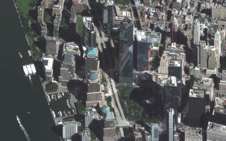
A more recent view of Lower Manhattan, where a 9/11 National Memorial and Museum has been built.

IKONOS captured this view of The Pentagon in Arlington, Virginia, on Sept. 15, 2001, showing the crash site of American Airlines Flight 77 and the damage caused to the left side of the government building.

Within a year of the 9/11 attacks, the west side of The Pentagon building was rebuilt, along with the National 9/11 Pentagon Memorial, which was dedicated in 2008 to those who lost their lives in the terror attacks.

This satellite image, taken on Sept. 13, 2001, captures the field in Shanksville, Pennsylvania, where United Airlines Flight 93 crashed.

The field in Shanksville, Pennsylvania, has since been turned into the Flight 93 National Memorial, run by the National Park Service.
The Pentagon in Arlington, Virginia, was also photographed by IKONOS on Sept. 15, 2001. The satellite views show the crash site of American Airlines Flight 77 and the damage caused to the left side of the government building.
Maxar's IKONOS satellite also observed the field in Shanksville, where United Airlines Flight 93 crashed. The satellite snapped views of the area on Sept. 13, 2001, showing the site of the crash, as well as a more recent view of the area, which has since been turned into the Flight 93 National Memorial, run by the National Park Service.
"These were the first unclassified satellite images released to the public of the 9/11 attack locations," according to a statement from Maxar Technologies.
Get the Space.com Newsletter
Breaking space news, the latest updates on rocket launches, skywatching events and more!
Images from Maxar's IKONOS satellite not only capture the three attack sites 20 years ago, but also more recent views as rebuilding efforts have taken place over the last two decades.
In addition to Maxar's IKONOS satellite tracking the attack sites from orbit, one American astronaut — NASA's Frank Culbertson — saw the tragic events of 9/11 unfold from space while working on the International Space Station. From about 250 miles (400 kilometers) above Earth, Culbertson saw a huge column of smoke streaming from Lower Manhattan where the Twin Towers fell and documented it for NASA.
The 9/11 terror attacks initiated the War on Terror, which became "the first major military campaign in history to leverage unclassified commercial satellite imagery for mission planning, monitoring and intelligence gathering," according to the Maxar statement. Satellites' geospatial intelligence (GEOINT) allows for "seamless intelligence sharing across U.S. combatant commands and with coalition partners."
In the decades since the attacks, Earth-observing satellites have grown much more sophisticated, with higher resolutions, better accuracy, greater collection capacity, faster agility and more spectral bands. In addition, methods for transmitting space-based data to Earth have also improved, allowing defense teams to more rapidly collect, downlink, upload and disseminate commercial satellite data, according to the statement.
GEOINT assisted in locating Osama bin Laden, who was killed on May 2, 2011 in Abbottabad, Pakistan, by the U.S. Navy SEAL Team 6. Maxar satellite imagery was used to study the structure of bin Laden's compound and create a simulation of the area, which aided in training the military teams that participated in the raid.
Earth-observing satellites not only play an important role in security and defence, but also aid in disaster monitoring and emergency response. Satellite imagery has proven especially useful for tracking severe weather events and environmental impacts, ranging from hurricanes and tsunamis to earthquakes, floods, fires and oil spills, from space.
Follow Samantha Mathewson @Sam_Ashley13. Follow us on Twitter @Spacedotcom and on Facebook.
Join our Space Forums to keep talking space on the latest missions, night sky and more! And if you have a news tip, correction or comment, let us know at: community@space.com.

Samantha Mathewson joined Space.com as an intern in the summer of 2016. She received a B.A. in Journalism and Environmental Science at the University of New Haven, in Connecticut. Previously, her work has been published in Nature World News. When not writing or reading about science, Samantha enjoys traveling to new places and taking photos! You can follow her on Twitter @Sam_Ashley13.