Satellite produces new map of Earth's gravity field
Posted: Fri, Apr 1, 2011, 7:56 AM ET (1156 GMT)
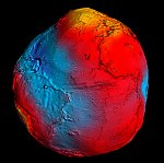 European scientists unveiled Thursday the most detailed map to date of the Earth's gravity field, produced from data collected by an ESA satellite. Scientists used the data collected by ESA's Gravity field and steady-state Ocean Circulation Explorer (GOCE) since its launch in March 2009 to produce the most accurate map of the Earth's geoid, the surface of equal gravitational potential. Scientists plan to use this new map for a variety of applications, from studying ocean currents and climate to seismology. Project officials said the spacecraft should be able to operate through the end of 2012, allowing further refinement of the gravity map.
European scientists unveiled Thursday the most detailed map to date of the Earth's gravity field, produced from data collected by an ESA satellite. Scientists used the data collected by ESA's Gravity field and steady-state Ocean Circulation Explorer (GOCE) since its launch in March 2009 to produce the most accurate map of the Earth's geoid, the surface of equal gravitational potential. Scientists plan to use this new map for a variety of applications, from studying ocean currents and climate to seismology. Project officials said the spacecraft should be able to operate through the end of 2012, allowing further refinement of the gravity map.
Related Links:
| <<previous article | next article>> |
|
news in brief
|
|
Senate committee advances Isaacman nomination to lead NASA
Posted: Sun, May 4 10:23 AM ET (1423 GMT) |
|
news links
|
|
Thursday, May 8
Industry Leader and Longtime Hughes CEO Pradman Kaul Dies
ViaSatellite — 6:50 am ET (1050 GMT) Elon Musk's Starlink gets govt nod in India for satcom service: What it means for users, pricing and more
Business Today — 6:48 am ET (1048 GMT) Elon Musk's internet company Starlink gets India approval: What does this mean? What services will you get? Explained
livemint — 6:48 am ET (1048 GMT) Elon Musk’s Starlink gets Indian regulatory go-ahead for satcom services
The Economic Times (India) — 6:45 am ET (1045 GMT) These students built a rocket, a satellite — and a national reputation
CSU Long Beach — 6:43 am ET (1043 GMT) |